Switzerland - Leica P30/P40 ultra-high speed 3D laser scanne

发布:admin时间:2021-09-01 点击数:
Leica measurement System ScanStation P30/P40, the 8th generation of 3D laser scanner, integrates Leica's high-precision Angle measurement ranging technology, WFD waveform digitization technology, Mixed Pixels Mixed pixel technology and HDR high dynamic range image technology, as well as The quality of Leica hardware. The P30/P40 has high performance and stability, and the scanning distance can reach 270m, meeting the requirements of various scanning tasks.
 
The main features
 
Two hundred years of precision instrument manufacturing technology, excellent scanning accuracy
One hundred years of manufacturing technology and research and development experience, hardware quality, to ensure that the instrument has higher performance
Angle measuring accuracy 8", ranging accuracy 1.2mm+10ppm, excellent precision index, to ensure accurate and reliable results
   
WFD waveform digital technology, accurate scanning and low noise
Scanning speed up to 1,000,000 points/SEC, ultra-high speed scanning can reduce field time and cost savings
Noise accuracy 0.5 mm @ 50 m, very low range noise
   
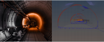
The scanning distance can be up to 270 meters to meet the requirements of various scanning tasks
The effective scanning distance can reach 270m@34% reflectance, and more scanning data can be obtained with fewer stations
The longer scanning distance can easily meet the requirements of terrain, mines, high-rise buildings and other long distance scanning
   
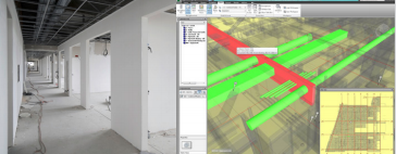
Custom scan resolution, point cloud density with your control
Customize scan resolution according to requirements, flexible and convenient
"Fine scanning" can be carried out for specific areas, increasing efficiency
   
Mixed Pixels technology makes scanning details sharper
New laser LIDAR system
Class I laser, harmless to human eyes, work more secure
   
Graphical wizard interface, easy to learn and use, easy to use
The airborne program uses graphical guide form, no training, easy to use
One-button operation, simple and convenient, set up the station to scan, save the operation time of scanning setting
   
Data storage integration, secure and convenient
Built-in 256GB SSD for good data storage
Support USB2.0 or data line for high-speed data transmission, convenient and fast
   
External high pixel SLR camera, scene restore more realistic
360° panoramic image can be obtained in 30 seconds, fast and convenient
Realistic color images meet the professional needs of special customers for point cloud color information


Application field
 
Subway, tunnel, municipal engineering and other infrastructure industry applications
 
The measurement method of infrastructure is transitioning from traditional single point measurement to laser scanning. The precision of measurement level and integrated data processing process provide you with a complete 3D laser scanning solution
 
Equipment modification, reverse modeling and other factory and ship industry applications
 
The Leica ScanStation P30/P40 can quickly acquire rich point cloud data and high-resolution images. The data can be seamlessly imported into professional design software for modeling, design, mapping and conflict detection, such as SmartPlant 3D, which can use point cloud for reverse modeling and fast factory digitization
 
Installation engineering, interior transformation and other building BIM industry application
 
For construction, installation, decoration and completion acceptance, Leica ScanStation P30/P40 can be used throughout the entire life cycle of a building to record and control all aspects of the construction process. By seamlessly integrating BIM with CloudWorx for Revit, the project can be tracked without having to be in the construction site. Ensure the quality of the project, so as to avoid duplication of labor costs and delays
 
Archaeological excavation, restoration and other archaeological industry applications
 
It can easily realize the acquisition, measurement and editing functions of massive point cloud data, and directly deliver the cross section line, which helps to determine the spatial relations of cultural relics, ancient buildings or archaeological sites. It can be used for information sharing, management and archiving, and data recording of archaeological sites, providing a powerful power for cultural relics protection, archaeological excavation and restoration
 
Field investigation, accident investigation and other public security industry applications
 
Its contactless measurement technology can easily be used to obtain details at traffic accidents and crime scenes. The scanner can quickly obtain high-precision 3D point cloud data of crime and traffic accident scene in a few minutes, which can be used for strong evidence extraction and scene reconstruction analysis
 

Home page
phone
Contact us